New Launch ATE9020 In Flight Water Inversion
Traditional UAV‑based hyperspectral water quality monitoring follows this workflow:
Fly → Land → Download data → Process with professional software → Radiometric correction → Geometric correction → Inversion modeling → Generate maps.
From start to finish, it takes at least half a day, often several days. By the time the results are ready, the pollutant plume has already drifted, algal blooms have spread, and the optimal response window has been missed.
The “high” in hyperspectral shouldn’t only refer to spectral resolution – it should also mean high timeliness.
01 New Product: ATE9020 UAV Hyperspectral Real‑Time Telemetry System
Optosky proudly introduces the ATE9020, with a core breakthrough in one sentence:
Real‑time inversion during flight – water quality parameters are output on the fly, with no post‑processing required.
02 Technical Highlights
① Single‑point hyperspectral + real‑time inversion engine
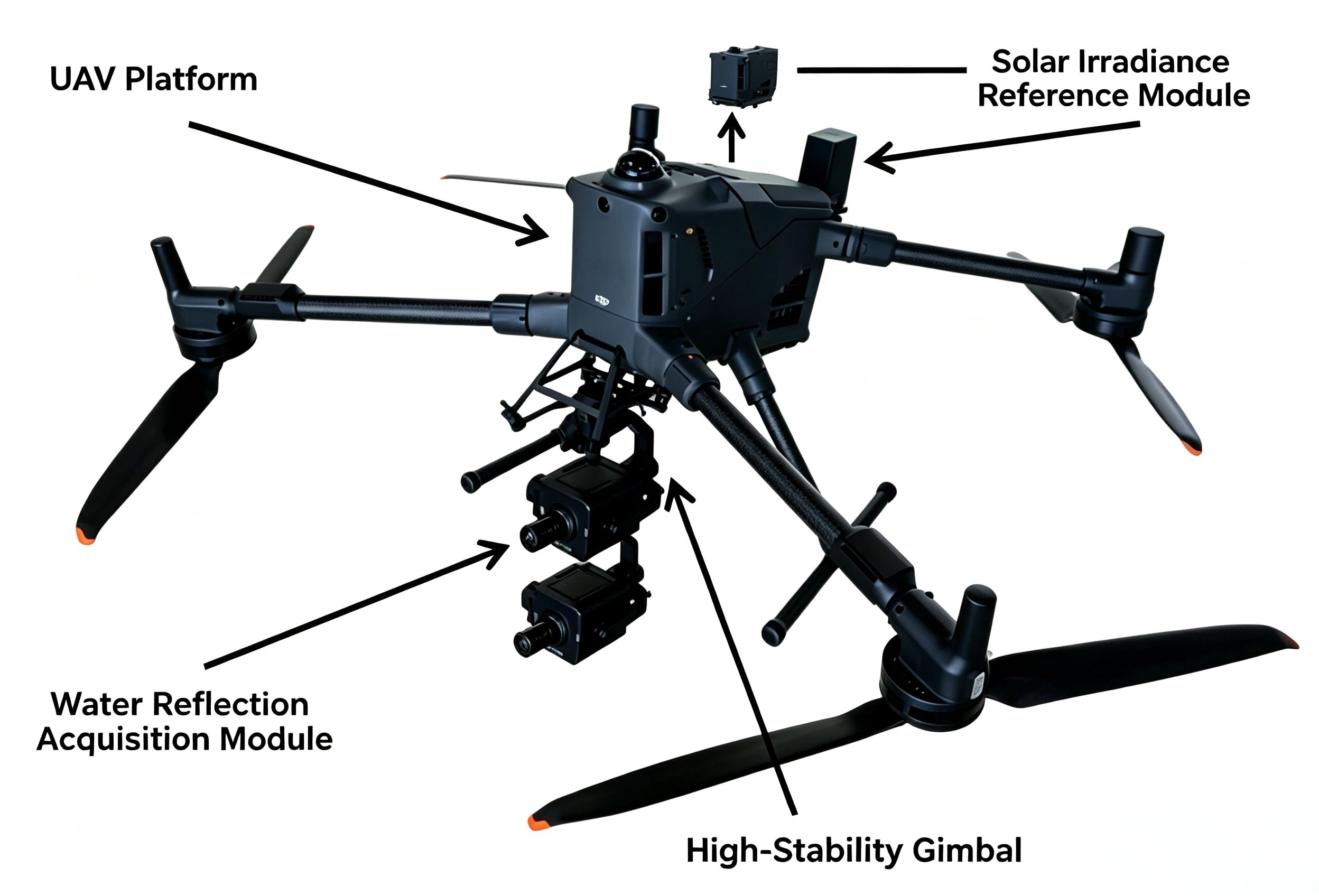
Adopting a single‑point spectral architecture (400–1000 nm, 1 nm resolution), the data volume is reduced by orders of magnitude compared to traditional push‑broom hyperspectral imagers. With an embedded inversion algorithm, it analyzes parameters such as chlorophyll‑a, COD, total nitrogen, total phosphorus, ammonia nitrogen, turbidity, suspended solids, and transparency in real time during flight.
② Real‑time water quality distribution maps transmitted back
The ground control software simultaneously displays spatial distribution heatmaps of water quality parameters alongside high‑definition video. The pilot can visually see “where is red, where is green” on the remote controller, pinpointing polluted areas or eutrophication hotspots immediately.
c
③ Video evidence + spectral analysis – dual‑mode synchronization
Integrated with a high‑definition zoom camera (2.8–12 mm, 4× optical zoom, 50 m infrared illumination), the system automatically locks onto spectrally anomalous areas with video. A complete evidence chain of “data + imagery” is captured in a single flight, eliminating the need for a second sortie.
④ Deep compatibility with DJI M350 / M400 RTK
Equipped with a 3‑axis brushless gimbal stabilization architecture, it withstands winds up to 12 m/s (Beaufort force 6), offers 55 minutes of no‑load endurance, and achieves centimeter‑level RTK positioning – giving every spectral data point an accurate geographic coordinate.
03 Application Scenarios
- Emergency patrol for algal blooms – identify high chlorophyll‑a zones in real time and delineate early‑warning areas immediately.
- Rapid anomaly detection in drinking water sources – mark abnormal COD and ammonia‑nitrogen points on the fly, with video evidence synchronized.
- Pollution source tracing at river outfalls – visualize total phosphorus and total nitrogen spatial distributions at a glance, quickly pinpointing discharge intervals.
- Ecological assessment of rivers and lakes – conduct a comprehensive water quality “health check” over large areas, generating a complete report in a single flight.
05 Closing
What the ATE9020 aims to achieve is not to make hyperspectral “more sophisticated,” but to make it “more immediate.”
From “compute after flying” to “see as you fly” – the response speed for water quality monitoring is now measured in minutes.
For more information, please contact:
Email: [email protected]
Web: www.optosky.net
A Good Raman Spectrum Starts with a Good Filter
Related Article