
Selecting the Right Remote Sensing Tool for Mineral Exploration: A Deep Dive into Optosky’s Hyperspectral ATH9010
2026-08-13
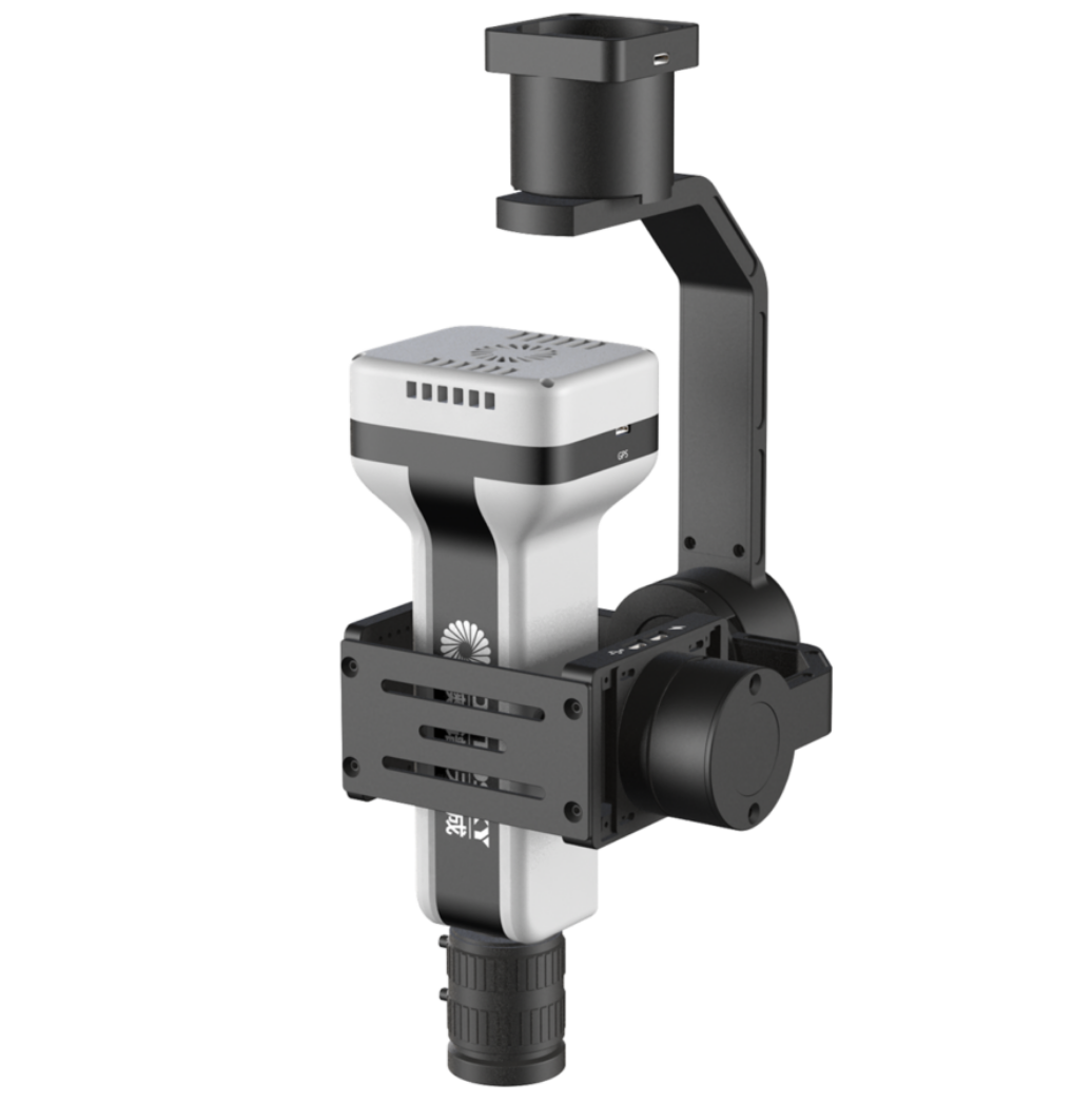
Why do the same types of remote sensing devices yield vastly different results in practice?
With the continuous advancement of remote sensing technologies, hyperspectral, thermal infrared, and multispectral instruments are increasingly applied in geological prospecting, mine supervision, disaster monitoring, and related fields. However, faced with diverse application needs, many users encounter the same challenge:
Should I choose hyperspectral or multispectral? Satellite, UAV, or ground‑based equipment? How do I balance detection accuracy with operational efficiency?
In reality, the value of remote sensing equipment lies not merely in "capturing images," but more importantly, in acquiring data that can support informed analysis and decision‑making based on the characteristics of the target objects.
In geological prospecting, hyperspectral remote sensing – with its rich spectral information – can identify surface alteration anomalies by analysing the diagnostic spectral features of different minerals, providing a critical basis for delineating prospective ore targets.
01 How to Choose for Prospecting and Exploration?
Hyperspectral Focuses on "Mineral Information"
Traditional remote sensing imagery mainly captures colour, texture, and spatial variations of ground objects. In contrast, hyperspectral remote sensing, through continuous spectral information, can further identify different mineral types and their assemblage characteristics.
During large‑scale regional prospecting, hyperspectral remote sensing can rapidly acquire surface mineral anomaly information. Combined with geological metallogenic condition analysis, it helps delineate potential ore‑bearing areas, providing a basis for subsequent drilling verification.
Suitable scenarios:
-
Metal mineral exploration
-
Alteration mineral identification
-
Anomaly extraction in mining areas
-
Surveys of exposed rock regions
Optosky’s hyperspectral remote sensing systems cover multiple bands from visible‑near infrared to short‑wave infrared, enabling fine spectral detection based on the distinct spectral signatures of various minerals.
02 UAV‑Based Hyperspectral vs. Traditional Remote Sensing
Flexibility Determines Application Efficiency
In complex terrains such as mountainous areas, deserts, and high‑altitude regions, traditional manual surveys suffer from long cycles, high costs, and significant safety risks.
UAVs equipped with hyperspectral sensors can quickly enter these challenging areas for high‑precision data acquisition, combining centimetre‑level spatial resolution with abundant spectral information.
Particularly in moderately high mountains, deeply incised areas, and regions inaccessible to personnel, airborne hyperspectral remote sensing plays a vital role in assisting prospecting evaluation by delineating anomalous zones.
03 Hyperspectral vs. Thermal Infrared
Many users tend to confuse hyperspectral and thermal infrared equipment.
In fact, the two address different types of information:
Hyperspectral remote sensing: answers "what is it?"
Identifies minerals, vegetation, water bodies, and other targets by analysing their spectral signatures.
ATH1010
Thermal infrared remote sensing: answers "where is the anomaly?"
Detects thermal anomaly areas through temperature variations, which can be used for geological anomaly analysis, disaster monitoring, etc.
In practice, the fusion of hyperspectral and thermal infrared data enables comprehensive analysis combining "spectral information + thermal anomaly information," thereby improving target detection capabilities.
04 Mine Supervision and Geohazard Monitoring
How to Choose the Right Equipment?
Beyond prospecting, hyperspectral and other remote sensing technologies are also widely used in mine supervision and geological disaster monitoring.
Monitoring of illegal cross‑border mining typically relies on high‑resolution optical remote sensing imagery. For slow subsurface deformation monitoring, InSAR technology provides more quantitative surface displacement information, achieving centimetre‑ to millimetre‑level accuracy.
Different application needs correspond to different equipment choices:
Mining area change monitoring
Recommended Equipment:High‑resolution optical remote sensing + UAV remote sensing
Mineral identification and analysis
UAV‑based hyperspectral + ground‑based spectral verification
Surface temperature anomaly detection
Thermal infrared remote sensing equipment
Geohazard risk identification
Optical remote sensing + InSAR deformation monitoring
For more information, please contact:
Email: [email protected]
Web: www.optosky.net
Grape Quality Inspection Made Smarter: Choosing the Right Spectral Tool with Optosky ATH1010/ATP Series
UAV-Hyperspectral Synergy: Redefining Precision in Ecological, Mineral, and Agricultural Surveys
Related Article

Discover Optosky’s air–ground collaborative hyperspectral solution for mine ecological restoration monitoring. Combining UAV hyperspectral imaging, fixed-point rotating-scan systems, and field spectroradiometers, it supports vegetation, soil, mineral alteration, and water environment monitoring for green mine evaluation and restoration acceptance.
Applications | Hyperspectral Mine Restoration Monitoring
Compare single InGaAs and CMOS+InGaAs detector architectures in hyperspectral imaging. Learn why both can cover 400–1700 nm, how visible-light-extended InGaAs works, and the trade-offs in calibration, spectral registration, and system integration for applications in agriculture, food safety, and industrial inspection.
Technology | Single InGaAs vs. CMOS+InGaAs in Hyperspectral Imaging
Discover how hyperspectral imaging combined with multi-feature fusion (PCA + 2DCOS + CARS) enables non-destructive three-level grading of chili pepper sunburn with 97.2% accuracy. Learn about the ATH3000 system and Optosky's customized solutions for horticultural crop quality inspection and damage classification.
Can Sunburned Chili Peppers Be Non-Destructively Graded? Hyperspectral Imaging ATH3000 Offers a New Answer
Discover the Optosky ATH9600 multi-lens UAV-borne multispectral imaging system—featuring 67° ultra-wide FOV, synchronous snapshot, 3.75 μm large pixel, and native DJI X-Port integration. Ideal for large-area farmland monitoring, orchard management, pest early warning, water quality inversion, and complex crop classification. Born for efficient, all-weather low-altitude remote sensing.
Born for Large-Area Remote Sensing! Optosky Releases the ATH9600 Multi-Lens UAV-Borne Multispectral Imaging System