
Product Introduction | ATH9030 UAV‑Based Hyperspectral Real‑Time Imaging System: Get Answers While in Flight
2026-03-02
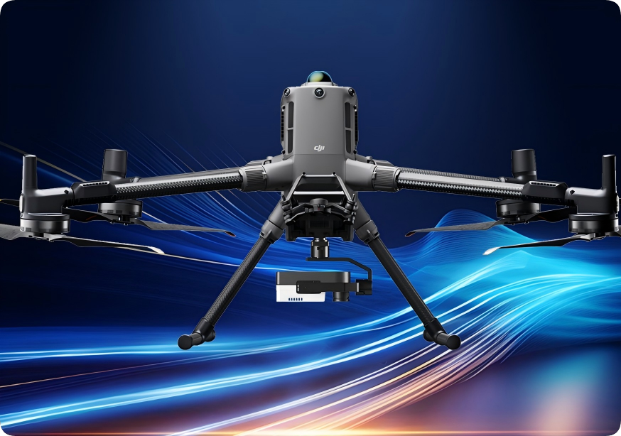
In traditional remote sensing operations, equipment installation is complicated, and carrying heavy loads outdoors is burdensome; operations rely on computers, making field control inconvenient; the flight process is non‑visual, and results must be transmitted back for analysis; data export depends on copying, leading to cumbersome and inefficient workflows.
In traditional remote sensing operations, equipment installation is complicated, and carrying heavy loads outdoors is burdensome; operations rely on computers, making field control inconvenient; the flight process is non‑visual, and results must be transmitted back for analysis; data export depends on copying, leading to cumbersome and inefficient workflows.
The Optosky ATH9030 UAV‑Based Hyperspectral Imaging System reshapes the remote sensing workflow with an integrated design, making deployment simpler, operation more efficient, and data more intuitive.
01 Product Performance and Advantages
-
Lightweight Integrated Design, Faster Deployment
Quick‑release structure and integrated gimbal design enable tool‑free installation; cables are highly simplified, compatible with multiple UAV platforms, improving field deployment and transition efficiency.
-
Analyze While Flying, Full Mission Control
Supports real‑time viewing of spectral images and mission coverage during flight, on‑site validation of data effectiveness with inversion results, and immediate re‑flights when issues are found, avoiding repetitive work.
-
Unattended Operation, Long‑Term Continuous Monitoring
Compatible with the ATPL900 UAV hangar, enabling automatic charging, mission scheduling, and data transmission back, supporting 7×24 autonomous operation to meet high‑frequency monitoring demands.
-
Authentic and Reliable Data: Scientific‑Grade Accuracy Calibration System
Say goodbye to image shadows caused by uneven illumination.
Equipped with a downwelling light sensor (DLS) as standard, it senses and corrects the impact of illumination changes on hyperspectral data in real time, improving data consistency and comparability. It supports stable data acquisition across different times and weather conditions, enhancing the credibility of quantitative analysis results.
-
Multi-Dimensional Perception Fusion: Multi Sensor Collaborative Expansion
Supports optional sensors such as thermal infrared cameras and LiDAR, enabling multi‑source synchronous acquisition. By fusing hyperspectral, thermal radiation, and 3D structural information, it provides a more comprehensive characterization of the physical and physiological features of ground objects, offering a richer data foundation for complex remote sensing applications.
-
Efficient Data Management, Hassle‑Free Fieldwork
Utilizes replaceable high‑capacity Micro SD storage to ensure data integrity during long continuous flights, simplifying data export and delivery processes.
02 Product Parameters
-
Spectral range: 400–1000 nm
-
Best hyperspectral resolution: <2 nm
-
Compact and lightweight, plug-and-play, integrated design
-
One-stop remote control: parameter setting, remote start/stop
-
Real-time spectral image viewing and inversion preview on remote controller
-
Built-in downwelling light sensor (DLS)
-
Remote flight planning and automated mission execution
-
Compatible with drone hangar for 7×24 unmanned autonomous operation
-
Cloud-based management and data transmission
-
Extended flight time: approx. 30 min, large cruise coverage
03 Serving Multi-Domain Remote Sensing and Analysis Missions
The ATH9030 UAV‑Based Hyperspectral Real‑Time Imaging System elevates hyperspectral remote sensing from “mission execution” to “continuous perception”, providing stable, reliable, and sustainable technical support for remote sensing applications across industries.
-
Agricultural Monitoring
Crop growth monitoring and agricultural condition analysis
-
Mining and Resource Monitoring
Remote sensing inspection in complex terrain
-
Ecological and Environmental Monitoring
Cotinuous observation of environmental factors such as water bodies and vegetation
-
Scientific Research and Technology Development
Remote sensing method validation and data acquisition
For more information, please contact:
Email: [email protected]
Web: www.optosky.net
The Optosky ATH9030 UAV‑Based Hyperspectral Imaging System reshapes the remote sensing workflow with an integrated design, making deployment simpler, operation more efficient, and data more intuitive.
The End of the Wait: Reagent-Free, Real-Time Water Quality Monitoring with Hyperspectral Analysis
Potato SPAD Estimation via UAV Hyperspectral & Machine Learning
Related Article

Discover Optosky’s air–ground collaborative hyperspectral solution for mine ecological restoration monitoring. Combining UAV hyperspectral imaging, fixed-point rotating-scan systems, and field spectroradiometers, it supports vegetation, soil, mineral alteration, and water environment monitoring for green mine evaluation and restoration acceptance.
Applications | Hyperspectral Mine Restoration Monitoring
Compare single InGaAs and CMOS+InGaAs detector architectures in hyperspectral imaging. Learn why both can cover 400–1700 nm, how visible-light-extended InGaAs works, and the trade-offs in calibration, spectral registration, and system integration for applications in agriculture, food safety, and industrial inspection.
Technology | Single InGaAs vs. CMOS+InGaAs in Hyperspectral Imaging
Discover how hyperspectral imaging combined with multi-feature fusion (PCA + 2DCOS + CARS) enables non-destructive three-level grading of chili pepper sunburn with 97.2% accuracy. Learn about the ATH3000 system and Optosky's customized solutions for horticultural crop quality inspection and damage classification.
Can Sunburned Chili Peppers Be Non-Destructively Graded? Hyperspectral Imaging ATH3000 Offers a New Answer
Discover the Optosky ATH9600 multi-lens UAV-borne multispectral imaging system—featuring 67° ultra-wide FOV, synchronous snapshot, 3.75 μm large pixel, and native DJI X-Port integration. Ideal for large-area farmland monitoring, orchard management, pest early warning, water quality inversion, and complex crop classification. Born for efficient, all-weather low-altitude remote sensing.
Born for Large-Area Remote Sensing! Optosky Releases the ATH9600 Multi-Lens UAV-Borne Multispectral Imaging System